For hikers in Switzerland · iPhone

Swiss hikes, planned and relived.

Trailframe finds the right hike for the day – trails, huts, trains and the weather up top in one plan. Record it, follow it offline, and relive it in 3D with every photo where you took it.

One email when it's ready. No spam, no account. Unsubscribe anytime.

  • No account
  • Your data stays on your iPhone
  • Built on open Swiss data

Aerial images © swisstopo

The right hike for today.

Tell Trailframe where, when and how long. It looks at the signposted trails around you, your grade, the weather on the high point, closures, huts and the trains there and back – and suggests a handful of tours that fit.

  • Day hikes, hut-to-hut trips and snow hikes – near a place or anywhere in Switzerland.
  • Walking times like on the yellow signposts, grades T1–T6, scenery and how busy it gets.
  • The forecast where it matters: on top. Sunrise, sunset, 0 °C line, wind, new snow.
  • Trains and buses to the trailhead, and the last connection home.
  • Closures, water, swim spots, restaurants and huts along the way.
  • Links to hut bookings, the avalanche bulletin and the official route page. Export as GPX.
ExampleMountain trail, grade T2

Oeschinensee panorama trail

Kandersteg · Bernese Oberland

3 h 5011.9 km↑ 351 m↓ 864 m

SceneryBusy on weekends
  • Sunny · 0 °C line 4,100 m · wind 10 km/h
  • Bern 07:39 → Kandersteg 08:47 · last train back 19:12
Start by 11:30
  1. Top station09:00
  2. Heuberg
  3. Oberbärglihut, food
  4. Oeschinenseeswim
  5. Kandersteg

Stand where the photo was taken.

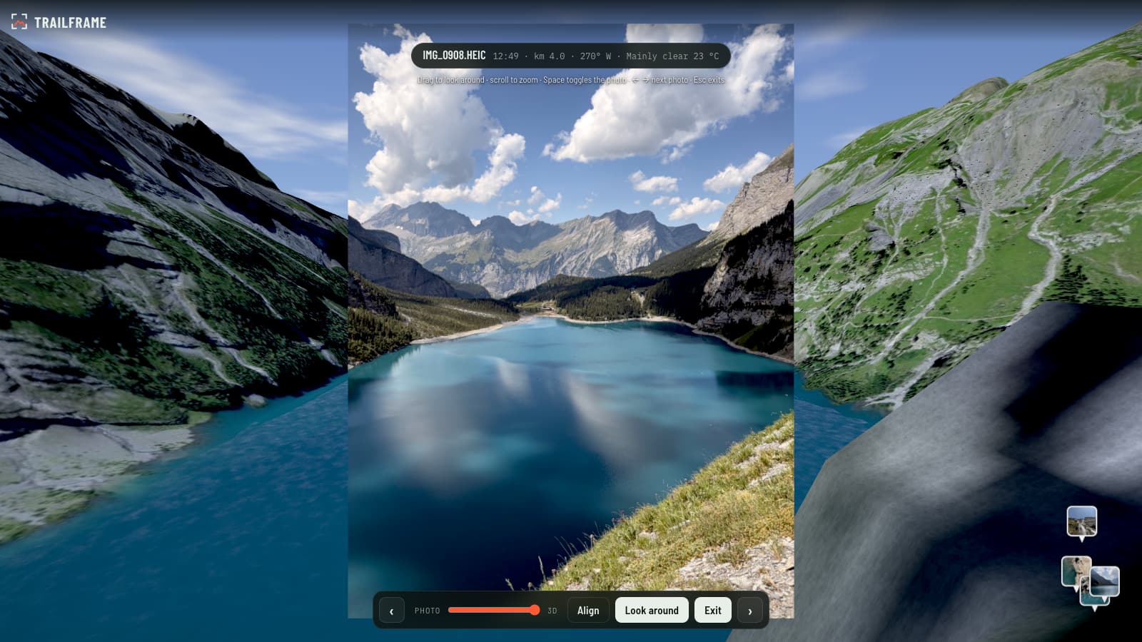
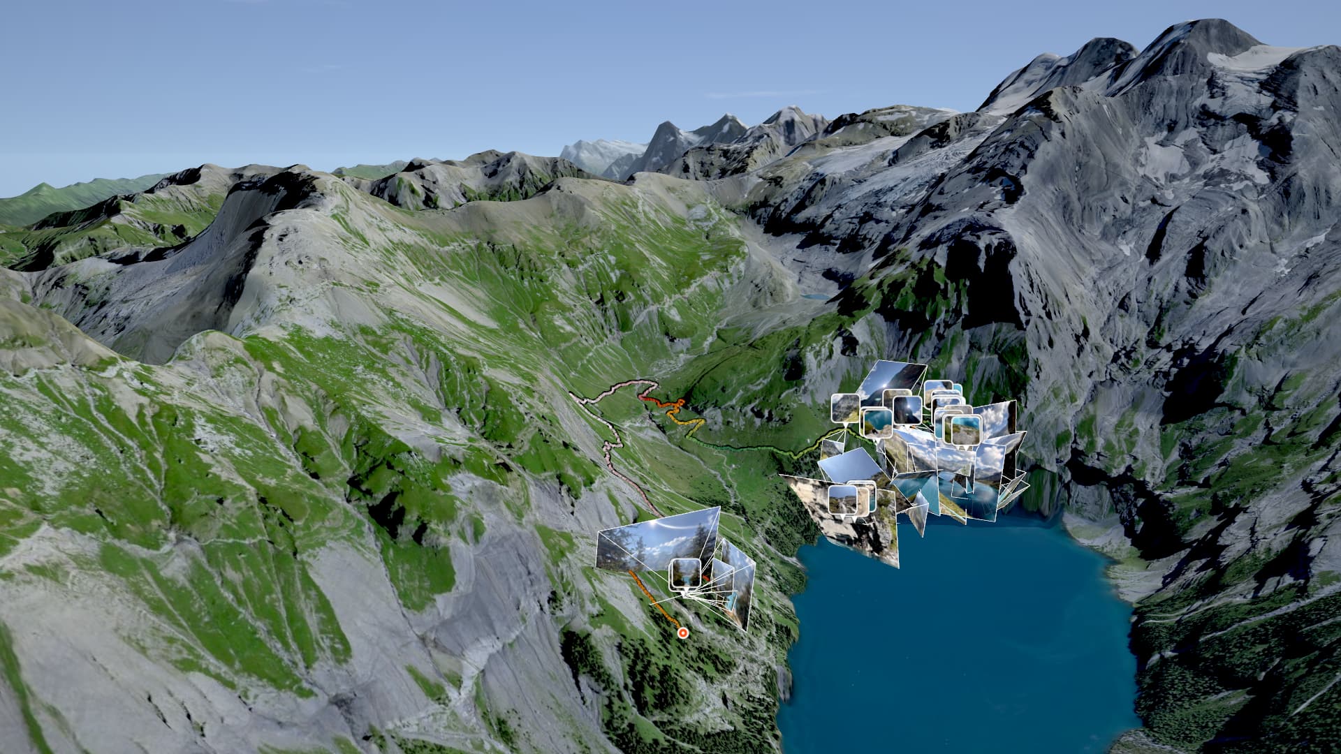
Trailframe puts your hike on real Swiss terrain and places every photo at its exact spot, direction and tilt. Fly along your route, step into a picture and watch it line up with the mountains around you.

Photo view in the 3D replay: a photo of the Oeschinensee placed where it was taken, with the slider between photo and 3D

Oeschinensee, Kandersteg. A real hike in the 3D replay.Aerial images © swisstopo

  • Every photo where you took it – position, compass direction, tilt and lens.
  • The day rebuilt: the weather and the sun at that hour.
  • Fly along, scrub the profile, follow your heart rate.
Record screen following a planned tour
Offline trail map of the route
SOS screen with emergency numbers and Swiss coordinates

On the trail, it has your back.

Record with GPS – also with the screen off. Follow a planned tour and get a nudge when you leave the route.

  • Recording with auto-pause and spoken kilometre cues, saved to Apple Health.
  • Follow a tour: progress, next stop, and a warning by vibration and voice when you're off route.
  • Offline trail map for your route – paths, huts, water, peaks.
  • SOS screen: Rega 1414, 112, 144, 117 and your Swiss coordinates, ready to read out.

Plans are suggestions based on public data. Always check signposts, conditions and the avalanche bulletin on site.

Hike analysis with splits and climbs
The You tab with personal records and gear

Every hike, worth keeping.

Your hikes from Apple Health arrive by themselves after you get home – analysed and ready to relive.

  • Splits, climbs, heart-rate zones and effort.
  • Best efforts and records, fitness and freshness over time.
  • Totals, goals and your personal heatmap of Switzerland.
  • Relive any hike in 3D – on your iPhone or a big screen.
Example

11.9 km5 h 22↑ 351 mavg 110 bpm6 photos

Your hikes stay yours.

No account.Open the app and go. No sign-up, no ads, no tracking.

On your iPhone.Health data, photos and recorded routes stay on your phone – unless you share a hike with friends yourself.

Open Swiss data.Routes, maps, weather and timetables come from public sources – credited, not scraped.

Data: © swisstopo · ASTRA/opendata.swiss · MeteoSwiss · opentransportdata.swiss · © OpenStreetMap contributors and others. All data credits

Questions

When can I get it?

Trailframe is in testing. Join the waitlist and you'll get one email when it's ready.

Is there an Android version?

Not at launch. Pick "Android" in the form – if enough of you do, it moves up the list.

Does it work outside Switzerland?

Recording, analyses and the 3D replay work anywhere. Planning covers Switzerland, because it's built on Swiss trail, weather and timetable data.

Does it work without reception?

Yes for recording, following a saved tour and its offline trail map. Planning needs a connection.

Where does the data come from?

From open public sources: the federal hiking-route data, swisstopo maps and aerial images, MeteoSwiss forecasts, the Swiss timetable and OpenStreetMap. Details are in the privacy policy.

Can it replace the official information?

No. Trailframe helps you choose and prepare. Signposts, local conditions, the avalanche bulletin and your own judgement always come first.

Do I need an Apple Watch?

No. Your iPhone is enough. Hikes recorded with an Apple Watch's workout app show up in Trailframe through Apple Health.

What happens to my email?

We use it only to tell you about the launch (and the beta, if you want). It's stored in the EU, never sold, and you can remove it with one click.

Who's behind it?

Adrian Kux (agsork studio), a hiker and developer in Berg. Trailframe is independent and not affiliated with any of the data providers.

Be there on day one.

Leave your email and tell us how you hike. We'll use it to decide what comes first – and send you one email when Trailframe is ready.

What do you like? (optional)
Your phone (optional)

Thanks – we'll count you in for Android.

One email when it's ready. No spam, no account. Unsubscribe anytime.